GEN 3.2 AERONAUTICAL CHARTS
1 Responsible Services
The Flight Procedure Design and Charting Group of the AIM prepares and produces all the charts.
The charts are produced in accordance with the provisions contained in the following ICAO documents:
| Annex 4 – | Aeronautical Charts |
| Doc 8697 – | Aeronautical Chart Manual |
| Doc 8168 – | Procedures for Air Navigation Services - Aircraft Operations (PANS-OPS) |
2 Maintenance of Charts
3 Purchase Arrangements
3.1 The charts as listed under para. 5 (except Aeronautical Chart - ICAO 1:500 000) are available free of charge from Estonian AIP.
3.2 The Aeronautical Chart - ICAO 1:500 000 listed under para. 5 can be obtained from:
| Post: | Estonian Transport Administration Aviation Division Lõõtsa 5 11415 Tallinn, ESTONIA |
| Tel: | +372 620 1200 |
| Fax: | NIL |
| E-mail: | info@transpordiamet.ee |
| AFS: | NIL |
| URL: | www.transpordiamet.ee |
Hour of operation: MON - FRI 0800 to 1630 LMT.
4 Aeronautical Chart Series Available
4.1 The Following Series of Aeronautical Charts are Produced:
- Aeronautical Chart (ANC) – ICAO 1:500 000;
- Aerodrome/Heliport Chart (ADC) – ICAO;
- Aircraft Parking/Docking Chart (APDC) – ICAO;
- Aerodrome Obstacle Chart (AOC) – ICAO - Type A (for each runway, if relevant);
- Precision Approach Terrain Chart (PATC) – ICAO;
- En-route Chart (ENRC) – ICAO;
- Standard Departure Chart – Instrument (SID) - ICAO;
- Standard Arrival Chart – Instrument (STAR) - ICAO;
- Instrument Approach Chart (IAC) – ICAO (for each runway and procedure type);
- Visual Approach Chart (VAC) – ICAO;
- Landing Chart (LDG).
4.2 General Description of Each Series
- Aeronautical Chart (ANC) – ICAO 1:500 000.
Chart is constructed on Lambert conformal conical projection. The aeronautical data shown are consistent with the use of the chart for low speed visual air navigation. It includes aerodromes, significant obstacles, elements of the ATS system, prohibited, restricted and danger areas, and radio navigation aids.
The chart provides information to satisfy visual air navigation and is also used as a pre-flight planning chart.
- Aerodrome/Heliport Chart (ADC) – ICAO.
Chart contains detailed aerodrome/heliport data to provide flight crews with information that will facilitate the ground movement of aircraft:- from the aircraft stand to the runway; and
- from the runway to the aircraft stand;
and helicopter movement:
- from the helicopter stand to the touchdown and lift-off area and to the final approach and take-off area;
- from the final approach and take-off area to the touchdown and lift-off area and to the helicopter stand;
- along helicopter ground and air taxiways; and
- along air transit routes.
It also provides essential operational information at the aerodrome/heliport.
- Aircraft Parking/Docking Chart (APDC) – ICAO.
Chart is produced for those aerodromes where, due to the complexity of the terminal facilities, the information to facilitate the ground movement of aircraft between the taxiways and the aircraft stands and the parking/docking of aircraft cannot be shown with sufficient clarity on the Aerodrome/Heliport Chart - ICAO or on the Aerodrome Ground Movement Chart - ICAO.
- Aerodrome Obstacle Chart (AOC) – ICAO - Type A (operating limitations).
Chart contains detailed information on obstacles in the take-off flight path areas of aerodromes. It is shown in plan and profile view. This obstacle information, in combination with an Obstacle Chart - ICAO - Type C, provides the data necessary to enable an operator to comply with the operating limitations of ICAO Annex 6, Parts I and II, Chapter 5.
- Precision Approach Terrain Chart (PATC) – ICAO.
Chart provides detailed terrain profile information within a defined portion of the final approach so as to enable aircraft operating agencies to assess the effect of the terrain on decision height determination by the use of radio altimeters.
- En-route Chart (ENRC) – ICAO.
Chart is produced for the entire Tallinn FIR. The aeronautical data include all international aerodromes, prohibited, restricted and danger areas and the air traffic services system in detail.
The chart provides the flight crew with information that will facilitate navigation along ATS routes in compliance with air traffic services procedures.
- Standard Departure Chart – Instrument (SID) - ICAO.
This chart is produced whenever a standard departure route - instrument has been established and cannot be shown with sufficient clarity on the Area Chart - ICAO.
The aeronautical data shown include the aerodrome of departure, aerodrome(s) which affect the designated standard departure route - instrument, prohibited, restricted and danger areas and the air traffic services system.
Chart provides the flight crew with information that will enable them to comply with the designated standard departure route - instrument from the take-off phase to the en-route phase.
- Standard Arrival Chart – Instrument (STAR) - ICAO.
Chart is produced whenever a standard arrival route - instrument has been established and cannot be shown with sufficient clarity on the Area Chart - ICAO.
The aeronautical data shown include the aerodrome of landing, aerodrome(s) which affect the designated standard arrival route - instrument, prohibited, restricted and danger areas and the air traffic services system.
Chart provides the flight crew with information that will enable them to comply with the designated standard arrival route - instrument from the en-route phase to the approach phase.
- Instrument Approach Chart (IAC) – ICAO.
This chart is produced for all aerodromes used by civil aviation where instrument approach procedures have been established. A separate Instrument Approach Chart - ICAO has been provided for each approach procedure.
The aeronautical data shown include information on aerodromes, prohibited, restricted and danger areas, radio communication facilities and navigation aids, minimum sector altitude, procedure track portrayed in plan and profile view, aerodrome operating minima, etc.
Chart provides the flight crew with information that will enable them to perform an approved instrument approach procedure to the runway of intended landing including the missed approach procedure and where applicable, associated holding patterns.
- Visual Approach Chart (VAC) – ICAO.
This chart is produced for aerodromes used by civil aviation.
The purpose of the Visual Approach Charts is to provide the pilot with a graphic presentation of the approach procedures to an aerodrome by visual reference.
The aeronautical data shown include information on aerodromes, obstacles, designated airspace, visual approach information, radio navigation aids and communication facilities, as appropriate.
- Landing Chart (LDG).
Chart provides an illustration of the aerodrome and its environs to facilitate the approach to the runway of intended landing and information necessary for landing and to facilitate rapid clearance of the runway after landing.
5 List of Aeronautical Charts Available
The chart series marked by an asterisk form a part of the AIP.
Title of Series | Scale | Name and/or Number | Price | Date |
|---|---|---|---|---|
En-Route Chart – ICAO* (ENRC) | 1 : 1 250 000 | Tallinn FIR | – | |
| ENR ENRC | 08 AUG 2024 | |||
Prohibited, Restricted and Danger Areas* (PRD) | 1 : 2 000 000 | Tallinn FIR | – | |
| ENR PRD | 05 SEP 2024 | |||
Military Exercise Training Areas and ADIZ* (TRA) | 1 : 2 000 000 | Tallinn FIR | – | |
| ENR TRA | 26 JAN 2023 | |||
Low-Level Flying Areas* (LFC) | 1 : 2 000 000 | Tallinn FIR | – | |
| ENR LFC | 18 APR 2024 | |||
Other Areas* (OTHER) | 1 : 2 000 000 | Tallinn FIR | – | |
| ENR OTHER | 18 APR 2024 | |||
Bird Migration Routes* (BIRD) | 1 : 2 000 000 | Tallinn FIR | – | |
| ENR BIRD | 26 JAN 2023 | |||
Free Route Airspace Chart* (FRA) | 1 : 9 500 000 | Tallinn FIR | – | |
| ENR FRA | 05 NOV 2020 | |||
Aerodrome/Heliport Chart – ICAO* (ADC) | 1 : 12 000 | Kärdla | – | |
| EEKA ADC | 31 | |||
| 1 : 12 000 | Kuressaare | – | ||
| EEKE ADC | 05 SEP 2024 | |||
| 1 : 8 500 | Kihnu | – | ||
| EEKU ADC | 25 MAR 2021 | |||
| 1 : 17 000 | Pärnu | – | ||
| EEPU ADC | 23 FEB 2023 | |||
| 1 : 8 500 | Ruhnu | – | ||
| EERU ADC | 04 NOV 2021 | |||
| 1 : 13 000 | Lennart Meri Tallinn | – | ||
| EETN ADC | 08 AUG 2024 | |||
| 1 : 15 000 | Tartu | – | ||
| EETU ADC | 05 OCT 2023 | |||
| 1 : 12 500 | Ämari | – | ||
| EEEI ADC | 25 FEB 2021 | |||
Aircraft Parking / Docking Chart – ICAO* (APDC) | 1 : 8 000 | Lennart Meri Tallinn | – | |
| EETN APDC | 18 MAY 2023 | |||
| 1 : 2 500 | Tartu | – | ||
| EETU APDC | 13 JUL 2023 | |||
| 1 : 3 500 | Ämari | – | ||
| EEEI APDC | 25 FEB 2021 | |||
Aerodrome Obstacle Chart – ICAO - Type A* (AOC) | 1 : 15 000 | Kärdla | – | |
| AOC A 14/32 | 11 AUG 2022 | |||
| 1 : 15 000 | Kuressaare | – | ||
| AOC A 17/35 | 02 NOV 2023 | |||
| 1 : 15 000 | Pärnu | – | ||
| AOC A 03/21 | 07 OCT 2021 | |||
| 1 : 15 000 | Lennart Meri Tallinn | – | ||
| AOC A 08/26 | 08 AUG 2024 | |||
| 1 : 15 000 | Tartu | – | ||
| AOC A 08/26 | 09 SEP 2021 | |||
| 1 : 15 000 | Ämari | – | ||
| AOC A 06/24 | 25 FEB 2021 | |||
Precision Approach Terrain Chart - ICAO* (PATC) | 1 : 2 500 | Lennart Meri Tallinn | – | |
| EETN PATC 08/26 | 08 AUG 2024 | |||
Instrument Approach Chart – ICAO* (IAC) | 1 : 350 000 | Kärdla | – | |
| EEKA RNP RWY 14 | 28 DEC 2023 | |||
| EEKA RNP RWY 32 | 28 DEC 2023 | |||
| 1 : 350 000 | Kuressaare | – | ||
| EEKE ILS or LOC RWY 17 | 18 APR 2024 | |||
| EEKE RNP RWY 17 | 18 APR 2024 | |||
| EEKE RNP RWY 35 | 18 APR 2024 | |||
| 1 : 350 000 | Pärnu | – | ||
| EEPU RNP RWY 03 | 05 SEP 2024 | |||
| EEPU RNP RWY 21 | 05 SEP 2024 | |||
| 1 : 350 000 | Lennart Meri Tallinn | – | ||
| EETN ILS or LOC RWY 08 | 08 AUG 2024 | |||
| EETN RNP Z RWY 08 | 25 FEB 2021 | |||
| EETN RNP H RWY 08 | 18 APR 2024 | |||
| EETN ILS or LOC RWY 26 | 08 AUG 2024 | |||
| EETN RNP Z RWY 26 | 25 FEB 2021 | |||
| EETN RNP H RWY 26 | 18 APR 2024 | |||
| 1 : 350 000 | Tartu | – | ||
| EETU RNP RWY 08 | 08 SEP 2022 | |||
| EETU RNP RWY 26 | 08 SEP 2022 | |||
| EETU ILS or LOC RWY 26 | 05 SEP 2024 | |||
| 1 : 350 000 | Ämari | – | ||
| EEEI VORTAC RWY 06 CAT AB | 11 AUG 2022 | |||
| EEEI VORTAC RWY 06 CAT CDE | 11 AUG 2022 | |||
| EEEI VORTAC RWY 24 CAT AB | 11 AUG 2022 | |||
| EEEI VORTAC RWY 24 CAT CDE | 11 AUG 2022 | |||
| EEEI ILS RWY 06 CAT AB | 11 AUG 2022 | |||
| EEEI ILS RWY 06 CAT CDE | 11 AUG 2022 | |||
| EEEI ILS RWY 24 CAT AB | 11 AUG 2022 | |||
| EEEI ILS RWY 24 CAT CDE | 11 AUG 2022 | |||
Visual Approach Chart – ICAO* (VAC) | 1 : 370 000 | Kärdla | – | |
| EEKA VAC | 18 APR 2024 | |||
| 1 : 370 000 | Kuressaare | – | ||
| EEKE VAC | 18 APR 2024 | |||
| 1 : 370 000 | Kihnu | – | ||
| EEKU VAC | 18 APR 2024 | |||
| 1 : 370 000 | Pärnu | – | ||
| EEPU VAC | 18 APR 2024 | |||
| 1 : 370 000 | Ruhnu | – | ||
| EERU VAC | 05 SEP 2024 | |||
| 1 : 200 000 | Lennart Meri Tallinn | – | ||
| EETN VAC | 13 JUN 2024 | |||
| 1 : 370 000 | Tartu | – | ||
| EETU VAC | 18 APR 2024 | |||
| 1 : 200 000 | Ämari | – | ||
| EEEI VAC | 18 APR 2024 | |||
Landing Chart* (LDG) | 1 : 35 000 | Kärdla | – | |
| EEKA LDG | 18 APR 2024 | |||
| 1 : 35 000 | Kuressaare | – | ||
| EEKE LDG | 05 SEP 2024 | |||
| 1 : 25 000 | Kihnu | – | ||
| EEKU LDG | 25 MAR 2021 | |||
| 1 : 40 000 | Pärnu | – | ||
| EEPU LDG | 22 FEB 2024 | |||
| 1 : 25 000 | Ruhnu | – | ||
| EERU LDG | 05 SEP 2024 | |||
| 1 : 75 000 | Lennart Meri Tallinn | – | ||
| EETN LDG | 13 JUN 2024 | |||
| 1 : 35 000 | Tartu | – | ||
| EETU LDG | 29 DEC 2022 | |||
| 1 : 120 000 | Ämari | – | ||
| EEEI LDG | 26 JAN 2023 | |||
Standard Departure/Standard Arrival Chart - Instrument – ICAO* (SID/STAR) | 1 : 1 130 000 | Lennart Meri Tallinn | – | |
| EETN RNAV SID RWY 08 | 11 AUG 2022 | |||
| EETN RNAV SID RWY 26 | 11 AUG 2022 | |||
| 1 : 350 000 | EETN RNP SID RWY 08 | 18 APR 2024 | ||
| EETN RNP SID RWY 26 | 18 APR 2024 | |||
| 1 : 650 000 | EETN RNAV STAR RWY 08 | 11 AUG 2022 | ||
| EETN RNAV STAR RWY 26 | 11 AUG 2022 | |||
| 1 : 700 000 | Tartu | – | ||
| EETU RNAV SID RWY 08 | 05 SEP 2024 | |||
| EETU RNAV SID RWY 26 | 05 SEP 2024 | |||
| EETU RNAV STAR RWY 08 | 05 SEP 2024 | |||
| EETU RNAV STAR RWY 26 | 05 SEP 2024 | |||
Bird Concentrations in the Vicinity of the Aerodrome* (BIRD) | – | Kärdla | – | |
| EEKA BIRD | 07 APR 2011 | |||
| – | Kuressaare | – | ||
| EEKE BIRD | 07 APR 2011 | |||
| – | Pärnu | – | ||
| EEPU BIRD | 07 APR 2011 | |||
| – | Tallinn | – | ||
| EETN BIRD | 07 APR 2011 | |||
| – | Tartu | – | ||
| EETU BIRD | 07 APR 2011 | |||
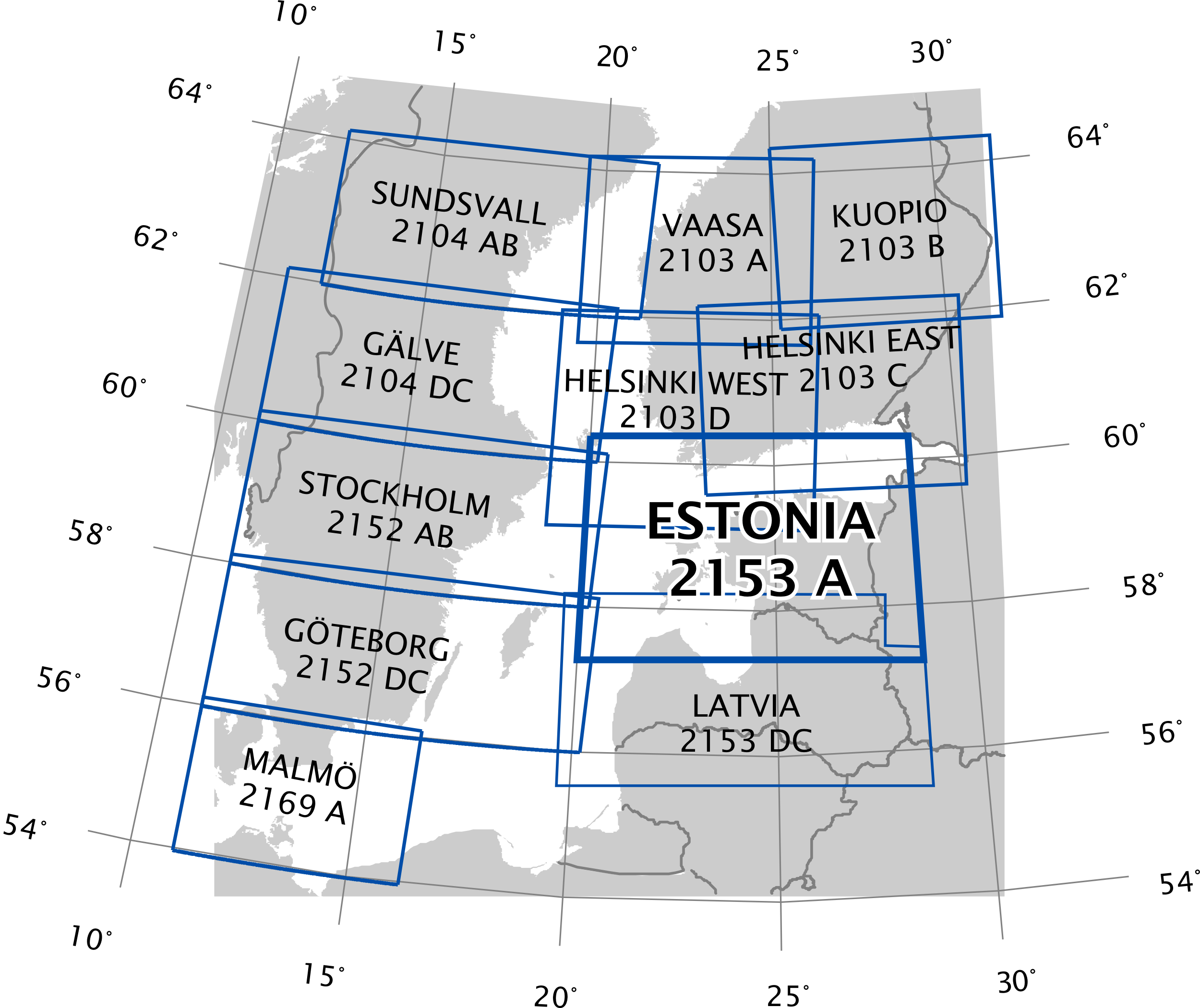
Aeronautical Chart – ICAO 1:500 000 (ANC) | 1 : 500 000 | ESTONIA 2153 A | 20.00 EUR (Postage is not included) | 18 APR 2024 |
6
Index to the Aeronautical Chart -
ICAO 1:500 000
7 Topographical Charts
| Post: | Estonian Land Board Mustamäe tee 51 10602 Tallinn, ESTONIA |
| Tel: | +372 665 0600 |
| Fax: | +372 665 0604 |
| E-mail: | maaamet@maaamet.ee |
| AFS: | NIL |
| URL: | www.maaamet.ee |
8 Corrections to Charts Not Contained in the AIP
Charts | Location | Corrections |
|---|---|---|
Consult ENR 5.4 and NOTAMs for latest changes concerning air navigation obstacles en-route. | ||
Aeronautical Chart - ICAO 1:500 000 | EEPA | Add Paslepa aerodrome. |
NIL | ||